Mapping as a service

HD maps for autonomous vehicles, captured and delivered.

We map your site with our own LiDAR and cameras, build the SLAM point cloud, remove the traffic that was moving through it, and draw the Lanelet2 lanes and traffic rules. You get a map your autonomy stack loads as is, without buying or learning any mapping software.

Process

From site visit to a map your stack loads

It starts with the site, the routes your vehicles will drive and the stack you run. We plan coverage from that and send a quote. After that, one team handles the whole job, so nothing gets lost between a survey crew and an annotation vendor.

Mapping pipelineOn site, a LiDAR (Ouster OS1-64), two ZED X stereo cameras and an RTK GNSS/INS (GeneSys ADMA) capture the site. SLAM fuses the scans and poses into one georeferenced point cloud. Dynamic object removal drops moving vehicles and people. Lanes, crosswalks, stop lines and traffic rules are annotated in Lanelet2 using Nimbus. Both maps are verified on site with a full-map review and an aerial-imagery drift check; if a gap is found, the site is captured again before leaving. The delivered Autoware map package contains pointcloud_map/ tiles, pointcloud_map_metadata.yaml, lanelet2_map.osm and map_projector_info.yaml.On siteProcessingDeliveredLiDAROuster OS1-64Cameras2× ZED X stereoGNSS/INSGeneSys ADMA, RTKSLAMFuses LiDAR scans andRTK poses into onegeoreferenced cloudDynamic objectremovalDrops the vehicles andpeople that movedduring captureLanelet2annotationLanes, crosswalks,stop lines and trafficrules, drawn in NimbusVerify on siteFull-map review on a laptop, plus an aerial-imagerydrift check, before the crew leaves the sitepoint cloudLanelet2 mapgap found: capture it again before leavingAutoware map packagemap/pointcloud_map/A.pcd B.pcd C.pcd …pointcloud_map_metadata.yamllanelet2_map.osmmap_projector_info.yamlLoads in Autoware as isData pathRe-captureMapping pipelineOn site, a LiDAR (Ouster OS1-64), two ZED X stereo cameras and an RTK GNSS/INS (GeneSys ADMA) capture the site. SLAM fuses the scans and poses into one georeferenced point cloud. Dynamic object removal drops moving vehicles and people. Lanes, crosswalks, stop lines and traffic rules are annotated in Lanelet2 using Nimbus. Both maps are verified on site with a full-map review and an aerial-imagery drift check; if a gap is found, the site is captured again before leaving. The delivered Autoware map package contains pointcloud_map/ tiles, pointcloud_map_metadata.yaml, lanelet2_map.osm and map_projector_info.yaml.On siteLiDAROusterOS1-64Cameras2× ZED XstereoGNSS/INSGeneSysADMA, RTKProcessingSLAMFuses LiDAR scans and RTK posesinto one georeferenced cloudraw cloudDynamic object removalDrops the vehicles and peoplethat moved during capturestatic cloudLanelet2 annotationLanes, crosswalks, stop lines andtraffic rules, drawn in Nimbusboth mapsVerify on siteFull-map review and an aerial-imagery drift check before leavinggap found: capture it again before leavingDeliveredAutoware map packagemap/pointcloud_map/A.pcd B.pcd C.pcd …pointcloud_map_metadata.yamllanelet2_map.osmmap_projector_info.yamlLoads in Autoware as isData pathLoop back to capture
Figure 1. Every job runs through the same pipeline. Each stage hands the next a file, and both maps are checked on site before the crew leaves.

Deliverables

What you get

One folder, in the layout Autoware’s map loader expects.

FileWhat it holds
pointcloud_map/The georeferenced point cloud as PCD tiles, with moving objects removed. Autoware loads only the tiles around the vehicle.
pointcloud_map_metadata.yamlThe tile size and where each tile sits, so the loader knows which tile covers which ground.
lanelet2_map.osmLanes, crosswalks, stop lines and traffic rules, aligned to the point cloud.
map_projector_info.yamlThe map projection, which ties map coordinates to latitude and longitude.

All open formats. You own the files and can edit them in any Lanelet2 or PCD tool.

Track record

575,976 m² mapped so far

About 142 acres, including Pinellas Suncoast Transit Authority’s FTA-funded automated bus yard demonstration and North Carolina A&T State University’s autonomous vehicle program.
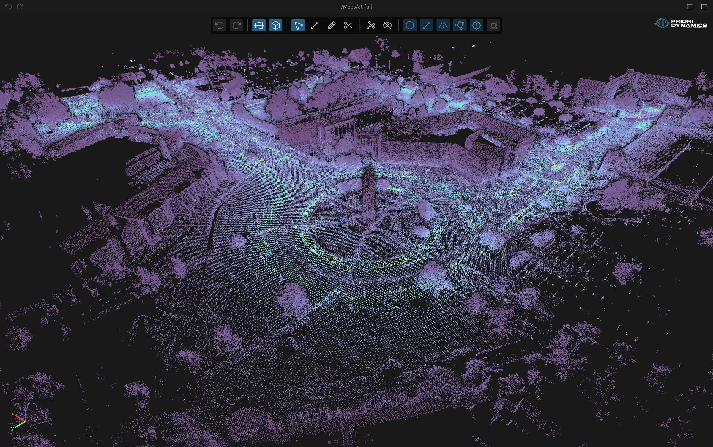
A full campus point cloud map from the NC A&T deployment
Figure 2. A full campus point cloud map from the NC A&T deployment.
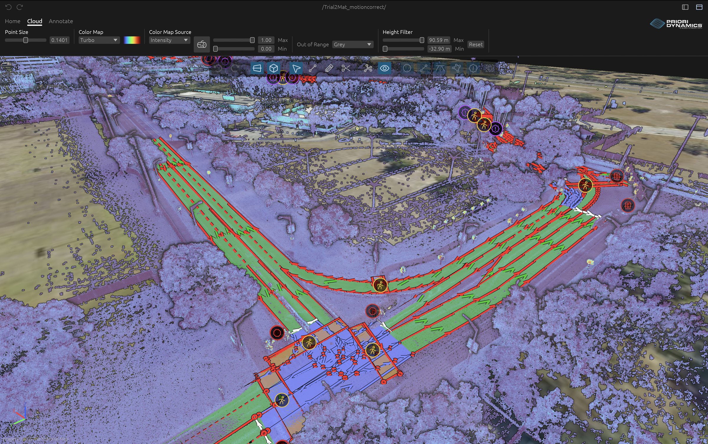
An intersection mapped in Lanelet2 over a LiDAR point cloud
Figure 3. An intersection annotated in Lanelet2: lanes in green, crosswalks and stop lines in red.

Get started

Request a quote

Tell us about the site and what the map is for. We will reply by email with questions or a quote.

Mapping quote request

Prefer email? Write to contact@prioridynamics.com.